


Washington State...July 2002
Just click on the pictures to enlarge photo's.
 |
 |
 |
 |
 |
 |
 |
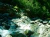
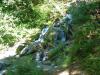
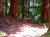
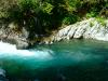
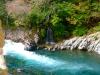
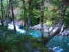
| Mountain Stream | Waterfall | Skyline Trail | Kayakers | Fishing | Camp spot | Wolf Bar |
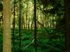
Washington's Olympic Peninsula is heaven on earth for seasoned class five paddlers. The Olympic rivers are like the spokes of a wheel, originating in the high central mountains and ending in the sea. The hardest of these rivers run through deep, alluring, unscoutable cracks in the earth that are only attempted by a few strong, adventurous kayakers each year. These rivers often run late into the summer, powered by a potent combination of rain and glacier melt in one of the few true rainforests in North America. I consider the Olympics to be the one of the last frontiers of hard exploratory Northwest Paddling; a place where the rivers are wild, untamed, and totally unforgiving.
To the North is the Mighty Elwha, which utterly dominates the Upper Northern side of the Olympics with it's big, burly rapids in a deep, formidable canyon. On the east side there is the Dosewallips, the Big Quilcene, and the Upper Hamma Hamma, all good class V runs with relatively easy access. On the west side, there are the upper gorges of the Queets, the Hoh, and the North Fork of the Quinault.
Only a handful of paddlers have attempted the the North Fork, or it's more challenging bretheren the Upper Queets and the Upper Hoh. In the Olympics river access is often a major challenge in and of itself, and the North Fork is no exception. Getting to the put-in for this run requires a twelve mile hike up into the mountains.